

The Old Testament Geography Gap
- Nathan Schneider
Let me begin by wishing you a very happy Thanksgiving, one filled with gratitude, humility, fellowship, and stuffing (because after all, isn’t stuffing the best part of the Thanksgiving meal? That’s really not a question but a statement of fact).
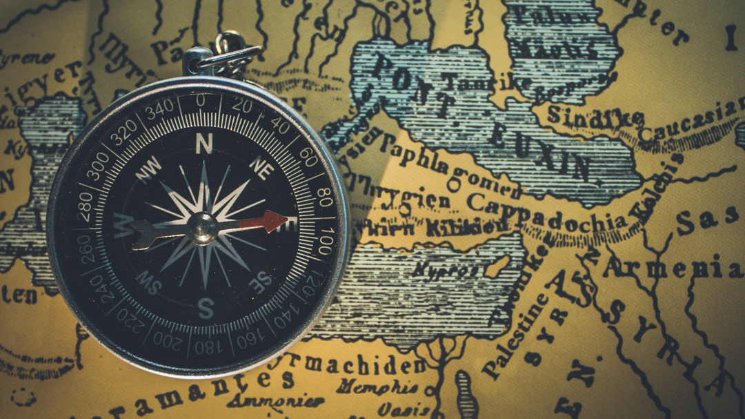
I took a much-needed hiatus last week to deal with the craziness that comes at this time of year with all the events scheduled throughout the day, but I’m back, and I thought that rather than writing a blog about Thanksgiving like everyone else on the internet is doing right now, I thought I’d write about something absolutely no one is writing about and talk about the topic of OT geography!
Now, I can hear it again…the moans, the groans. First it was grammar, now it’s geography! Why am I talking about all those subjects everyone hated when they were in school? Well, it turns out there’s an actual use for them.
Let’s just start by pondering for a moment our own geographical context. Think for a moment about the land and the climate of Alaska. How does the weather, the landscape and topography, the location, the food and agriculture, the resources and trade, the transportation routes, etc.—how do all these things impact what it’s like to live in Alaska?
The reality is that all of these things have an integral role in how we live our lives. We don’t really have to think too hard about them. They are ingrained within our cultural identity. Geography matters to us, and we adapt our lives to that existential reality.
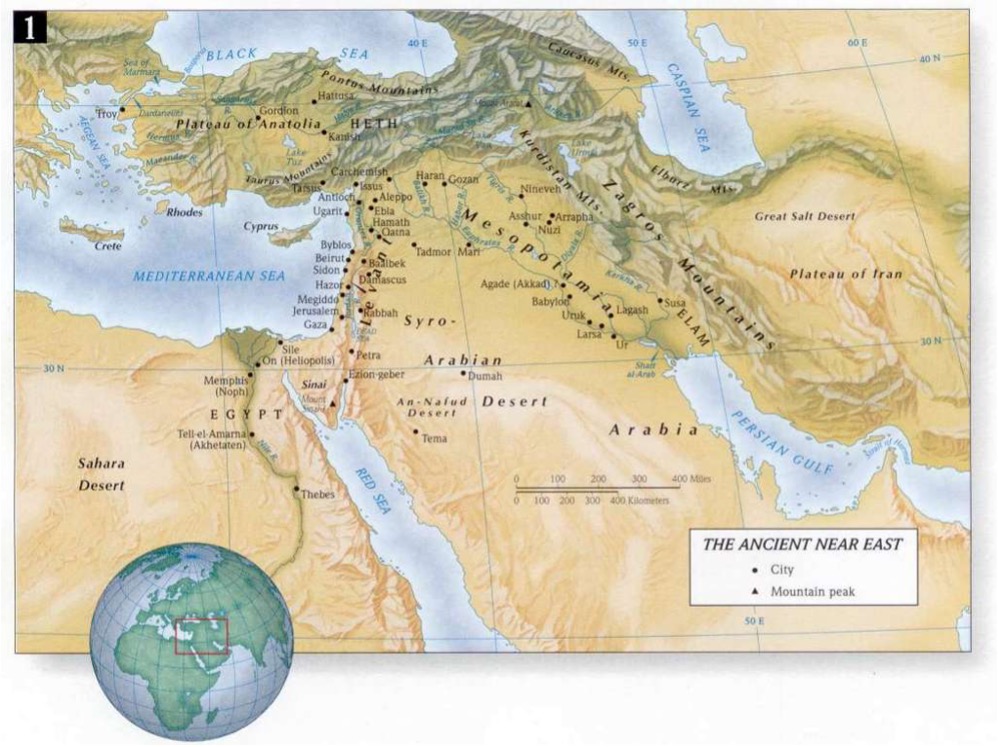
Why, then, would we expect anything different from the biblical figures who lived in the Ancient Near East (ANE)?
the land and climate of the Middle East played a significant role in how the Israelites lived and the events that transpired during the 2000+ year history of the Old Testament. As one scholar put it, “The history of the Israelite nation developed within a specific geographical context. For this reason, the Bible takes geography seriously. It records real events taking place in time and space. The Bible is not a portal into an artificial and contrived Narnia-like literary history” (Andrew E. Hill and John H. Walton, A Survey of the Old Testament [Grand Rapids: Zondervan, 2009], 35.) We must move past the seemingly static, two-dimensional text of our Bibles and see the events as the authors saw them: real and three-dimensional.
What we’re facing in this is another OT gap. And unlike the others, which are figurative and conceptual, this one is as real as it gets. It’s a literal, geographical gap that exists between us and the figures of the biblical text. As Curid and Barrett put it,
As any student of scripture quickly learns, the Bible was not written in a vacuum. Its books are set in specific geographic locations in the Near East during specific times in history, and these factors greatly affect how a book should be understood and interpreted. At the same time, the authors of Scripture often assume their audiences already understood the context in which their messages were set (since that was the audiences’ context as well), so they did not bother to describe these details fully in their books (John D. Currid and David P. Barrett, Crossway ESV Bible Atlas [Wheaton, IL: Crossway, 2010], 13).
The Land of Canaan
It is not inaccurate to state that the land of Canaan is the most significant piece of real estate on the planet. The New Testament tells us that this is where history will consummate when Christ ushers in His earthly kingdom. But in the Old Testament, this small piece of land carried even more significance.
The Fertile Crescent
Canaan is part of the southwestern portion of a vast sickle of land known as the Fertile Crescent. Bordered on the west by the Mediterranean Sea, on the south by the Syrian Desert, and on the north by mountain ranges, this sickle of land is known for being both habitable and cultivable.
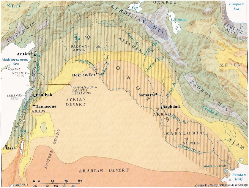
In comparison to Mesopotamia, the land of Canaan is actually the driest and least fertile portion of the Fertile Crescent. It is also the smallest. In fact, the land of Canaan is a surprisingly small piece of real estate. It stretches from Dan in the north to Beersheba in the south, a length just under 150 miles. It is bordered on the east by the Mediterranean Sea and on the west by the Jordan River, its width varying between 30 miles at the Sea of Galilee and 85 miles at the southern end of the Dead Sea. All told, the land totals some 6K to 7K square miles, roughly the size of Connecticut and Delaware combined.
Topography
The land of Canaan varies extensively in climate, landscape, and topography. This small area contains plains, deserts, forests, mountains, lakes, and rivers. At the northern extremity, Mt. Hermon stands at nearly 9,200 feet above sea level. Water flowing from the western slopes of Mt. Hermon course into the Jordan River and ultimately descend to the Dead Sea at almost 1,300 feet below sea level. These two geographical locations are barely 100 miles from each other.
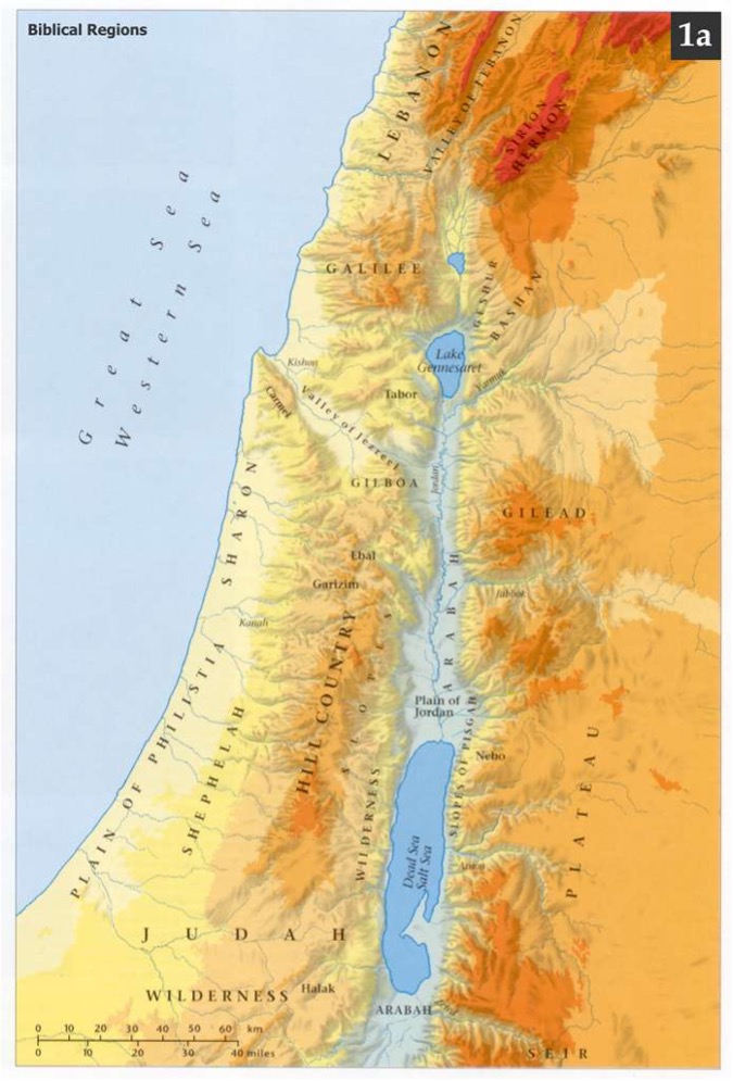
Climate
The extreme topographical variations also give Canaan the most varied climate than any other land of comparable size. Temperatures at Jerusalem range from 26° F to 107° F while the coastal plain is warmer, similar to Florida’s climate. The Jordan Valley around the Dead sea is subtropical and temperatures can reach 120° during summer months.
Rain falls in the cooler months, when winds from the west bring moisture over the comparatively cooler land area. Snow is relatively rare and occurs in the higher elevations, but hailstorms occur occasionally, causing damage to crops and herds. In the summer, winds from the east carry cool air from the sea, providing relief from the heat, while winds from the south and east bring scorching heat and dust. During the rainy season, winds can accompany precipitation and can be destructive.
Location
Yet the land of Canaan has known a significance throughout history far out of proportion to either its size or population. That is because this small, seemingly insignificant plot of ground is strategically located between two massive geographical regions. With water on the west and arid desert on the east, the land of Canaan forms a natural land bridge between Africa and Asia. This made Canaan of massive import both militarily and commercially. Egypt, to the southwest, was a major exporter of agricultural products supplied by the fertile nutrients of the nation’s major natural resource, the Nile River. Babylon, to the north, was less fertile and required many food needs. Naturally, this had a major impact on Canaan.
The importance of trade and commerce in the region made the land of Canaan a critical region. The various international powers asserted military influence in Canaan on a regular basis. Since these major players usually comprised empires located in either Mesopotamia (Assyria, Babylon, Medo-Peria, etc.) or Egypt, this narrow stretch of land was a regular location for major military engagement.
Consider, for a moment, the strategic importance of the land of Canaan against the overall backdrop of the Ancient Near East. Now consider the statement of Deuteronomy 7:7, where Moses tells Israel, “Yahweh did not set His love on you nor choose you because you were more numerous than all the peoples, for you were the fewest of all peoples.” Why would God choose to place a seemingly insignificant nation in such a strategically important and potentially insecure location? Quite simply, if Israel were to survive, they would have to trust Yahweh implicitly and rely on his protection in order to carry out their mission to be a channel of blessing to the peoples of the earth. It also meant that as the heathen nations passed through the land, they would certainly be exposed to the religion of Israel. In fact, God counted on this happening and promised Israel that if they obeyed the stipulations of the covenant, they would experience untold blessings which would capture the attention of the nations and draw them to worship Yahweh.
Geography and interpretation
What significance does geography have on our understanding and interpretation of the Old Testament? Consider the following examples.
Covenant Blessings and Curses
Deuteronomy 11:29-30 instructed Israel, upon entering into the land of Canaan to “place the blessings [of the covenant] on Mount Gerizim and the curse on Mount Ebal.” Again, in Deutereonomy 27:12-13, Moses gave the people a similar charge: When you cross the Jordan, these shall stand on Mount Gerizim to bless the people: Simeon, Levi, Judah, Issachar, Joseph, and Benjamin. For the curse, these shall stand on Mount Ebal: Reuben, Gad, Asher, Zebulun, Dan, and Naphtali.
Now, consider the photo below, picturing Mount Ebal and Mount Gerizim, with the town of Shechem between them. Which one is Ebal and which is Gerizim? How do you decide?
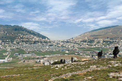
The answer to this question involves knowledge of Israelite culture and geography. First, consider the statement in Ecclesiastes that “a wise man’s heart directs him toward the right, but the foolish man’s heart directs him toward the left” (Eccl 10:2). This seemingly simple statement reveals the cultural connotations of the right and left hand.
In Israel, as in most Ancient Near Eastern cultures and in some contemporary Third World cultures, the left hand is responsible for some of life’s unsanitary acts. It was culturally taboo to contact people with the left hand so that over time, the left hand became synonymous with the hand of cursing, while the right hand was the hand of blessing. This is clearly seen in two other passages:
Joseph took them both, Ephraim with his right hand toward Israel’s left, and Manasseh with his left hand toward Israel’s right, and brought them close to him. But Israel stretched out his right hand and laid it on the head of Ephraim, who was the younger, and his left hand on Manasseh’s head, crossing his hands, although Manasseh was the firstborn. . . . When Joseph saw that his father laid his right hand on Ephraim’s head, it displeased him; and he grasped his father’s hand to remove it from Ephraim’s head to Manasseh’s head (Gen 48:13-14, 17).
All the nations will be gathered before Him; and He will separate them from one another, as the shepherd separates the sheep from the goats; and He will put the sheep on His right, and the goats on the left (Matt 25:32-33).
Thus, whichever mountain is on the right side is sure to be the mountain of blessing, while the left is reserved for the pronouncement of the curses.
However, there is another factor to consider: the direction of the photo. The town of Shechem lies just to the east of the two hills. When compared with the previous photo, it becomes apparent that the photo above was taken from the east looking west. This is where Ancient Near Eastern geography comes into the play.
Modern day maps place north at the top, based on our understanding of the magnetization of the earth and the rotation of the globe in relation to the sun. Maps in the Ancient Near East, however, oriented their maps to the east, most likely because the rising sun provided the most consistent means of determining direction. This fact helps us to understand why Moses would have chosen Mount Gerizim as the mountain of blessing. Oriented east, Gerizim stood to the right of Shechem—the side of blessing—while Ebal stood on the left. What seems like a trivial and inconsequential decision to modern western readers was deeply rooted in the culture and geographical psyche of the Ancient Near Eastern mind.
Northern Israel’s Substitute Worship
When Solomon died, he passed the kingdom on to his son, Rehoboam, along with a large national debt and heavy tax rate that paid for his massive building projects. Shirking the recommendation of his older counselors who encouraged him to lower the national tax, Rehoboam followed the support of his younger counselors and increased the national tax. That paved the way for the ten northern tribes, led by the returned exile Jeroboam I, to revolt, forming a second Israelite kingdom.
One of the moves Jeroboam I made was to establish two cult centers in the twos of Dan and Bethel:
Jeroboam said in his heart, “Now the kingdom will return to the house of David. If this people go up to offer sacrifices in the house of the LORD at Jerusalem, then the heart of this people will return to their lord, even to Rehoboam king of Judah; and they will kill me. . . . So the king consulted and made two golden calves, and he said to them, “It is too much for you to go up to Jerusalem; behold your gods, O Israel, that brought you up from the land of Egypt.” He set one in Bethel, and the other he put in Dan.
Obviously, Jeroboam wanted to break the solidarity of the northern and southern tribes, and he knew that a yearly trek to Jerusalem for worship would attract the people to reunite the two kingdoms. So Jeroboam established a substitute system of worship. The golden calves were actually bulls and were meant to be visible images or pedestals on which the invisible Yahweh supposedly rode. By making these calves, Jeroboam was creating a syncretistic religion by uniting the worship of Yahweh with pagan symbols. He then placed these two pagan images in two different towns in northern Israel.
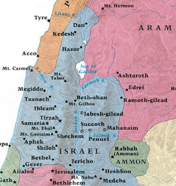
Consider the map of northern kingdom below. Why would Jeroboam establish alternative centers of worship at Dan and Bethel?
These two locations were most likely chosen because they were ideally located in the northern kingdom. With a cult center at the north and south ends, no one in the northern kingdom had to travel to the opposite end of the kingdom to worship. What was more, no one would need to travel to the southern kingdom at all.
Summary
Just as language impacts how Scripture should be interpreted, so geography, topography, and climate played a significant role in the thoughts and actions of people in the Old Testament. God specially chose the land of Canaan as the location to establish His chosen people. And the unique characteristics of that land had a tremendous impact on the events we read about throughout the Old Testament.
If you’re interested in reading more about the geography of the Bible are need a good resource for Bible study, here are some recommended resources to consider:
- Beitzel, Barry J. The New Moody Atlas of Bible Lands. Chicago: Moody Press, 2009.
- Cleave, R. L. W. The Holy Land Satellite Atlas. 2 volumes. Nicosia, Cyprus: Røhr Productions, 1999.
- Currid, John D., and David P. Barrett. Crossway ESV Bible Atlas. Wheaton, IL: Crossway, 2010.
- The Bible – Bible Atlas
- BibleMap.org
- BiblePlaces.com